Common history
People have lived in or around Stoke Newington Common for millennia.
Pre-history
The
area has a rich archaeological heritage and is quite famous for the thousands
of early stone-age (‘Lower Palaeolithic’
– 450,000 to 100,000 BC) hand-axes and other tools and items found here.
These have been dated to approximately 400,000
years ago. Most were found during the extensive house building in this area in the late 18th
century. Most are now held by the British Museum, the Museum of London, Vestry House Museum in Walthamstow, and in Bromley Museum.
Below is a picture
of flint axes found locally and now on display in the Museum of London. Numbers 10 and 12 were
found in Stoke Newington Common, number 11 in Clapton, and number 9 in Abney
Park Cemetery.

This map shows where some stone age and Roman items were found:
Roman times
Later on, the area was likely to have been used by the Romans, as evidence of Roman burials and other artefacts were found near Stamford Hill (then called ‘Ermine Street’) and the Upper Clapton Road. One of the Roman stone coffins found contained a female skeleton (Pozorski and Higgs, 2009).
More recently
It is believed that people started settling in Stoke Newington in the Anglo-Saxon period, and that the name 'Stoke Newington' came from the Saxon place-name ‘new town in the wood’ (Weinreb & Hibbert 1983, p851). By medieval times, a number of roads had been developed in the area and housing expanded, mainly along the current High Street/ A10, Shacklewell Lane and Upper Clapton Road.
The Common was originally called 'Cockhanger Green', then 'Newington
Common', but Stoke Newington Common has been the name since at least 1870. Historically, as the name suggests, the Common was commonly owned
land: local people used their rights to use the Common to graze their livestock. It
was considerably larger than it is today, as strips around the edge were used for private farming and housing in the 18th and 19th centuries. The maps below are dated 1745 and 1761 respectively.


Although the boundaries of the Common have shrunk considerably, the roads which now dissect it, connecting Stamford Hill with Clapton and Shacklewell, (Northwold Road, Rectory Road and Stoke Newington Common), have been in approximately the same location for a few hundred years, although some started out as footpaths).


Development of housing 1788 onwards
The earliest housing around the Common was on the west side: Sanford Terrace is the only surviving stretch of the terraces, built in 1788–90, which used to run the entire length until the 1970s. The remainder were demolished to make way for Smalley Road Estate.As late as
1870, the areas to the north and south were fields and market gardens,
with three large houses. Speculative development of terraced avenues
commenced in the 1870s, first in the streets south of the Common, then to
the north. Much of the Stoke
Newington area was used to extract brick making clay, presumably for some of
this housebuilding, and evidence of 19th century brickearth pits have been
found (Weinreb & Hibbert 1983, p851).
 |
| Raines Court today - on site of old dairy |
In 1880,
Gibson Gardens – an example of early, quality, tenement dwellings for
working-class people – was built at the north-west corner of the
Common. Gibson Gardens used to look over Raine’s Dairy to the Common.
The latter is now the Peabody Trust’s development of Raine’s Court.
 |
| Do you recognise this spot? |
Other interesting bits of local history

The area has a long history of interesting residents, including many non-comformists and campaigners against the slave trade. Find out about Florence du Vergier and why she is commemorated on the Common.
World War 1
The first Zeppelin bomb fell on 16 Alkham Road, N16, at 11pm on the 31st of May 1915, marking the first ever aerial bombing of London in the First World War. A plaque now commemorates the event.

The Zeppelin’s surprise bombing raid that night continued
over other parts of Hackney, Tower Hamlets and Waltham Forest. Bombs were dropped on Nevill, Cowper, Balls Pond, Shakespeare and Allen Roads. Incredibly although the
bombs started a fire at 16 Alkham Road, no one was injured there. But overall
that night, seven people died and 35 were injured. More info
World war 2
Residents
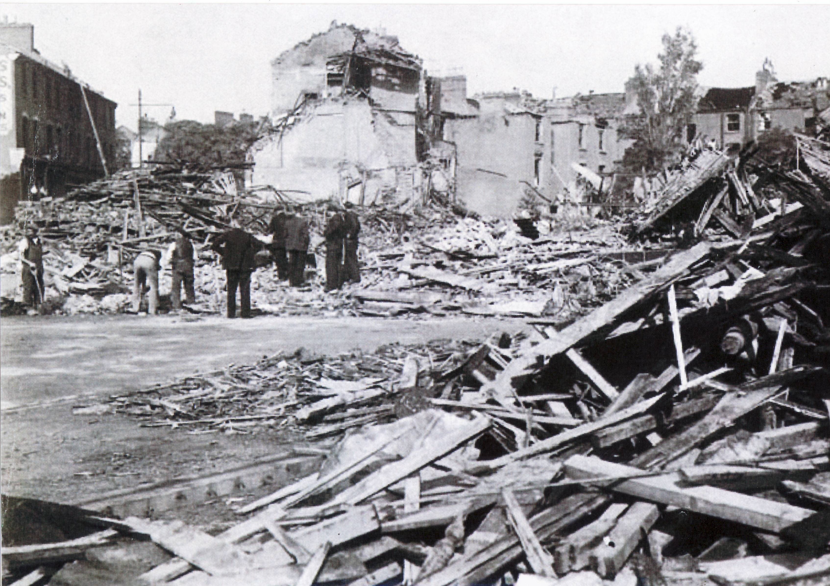
in this area suffered a lot during the second world war, as indicated by the
extensive bombing of local houses. Photograaphs from the Hackney Archives below illustrate the devastation of 1-17 Benthal Road, Maury Road, Northwold School, Kyverdale Road and Alkham road.


The Common itself is said to have been raised several feet or more by the amount of rubble deposited there in the post-war rebuilding effort.
1970's and 1980's


More 1980's photos here: hackneyinthe80s.com/
Further information and links
- The Hackney Archives holds many photographs and other records, which you can search by area or by theme, online or in person. Visiting the Archives also allows you to view several early maps of the area.
- Hackney Museum holds has many items found in this area, including an anglo-saxon boat found near Springfield Park.
- For many years, loacl historians Amit Dotan, Sean Gubbins and Nick Perry have been cataloguing Stoke Newington's history and are very generous in sharing imageea dn other interesting pieces they have unearthed old images; https://twitter.com/HistoryOfStokey
- Hackney Society http://www.hackneysociety.org/
- The Layers of London website allows you to search different areas and themes
- A website Bombsight allows you to look up where WW2 bombs fell in your area/ street
- Exhibits at the Geffrye Musem, based in the former Ironmongers' Company almshouses (1715), illustrate Hackney's past extensive furniture and cabinet-making trades.

